At about 4:45 in the morning on April 10, 2018, a truck carrying labourers and their families was travelling along the Pune-Satara highway when it reached one of the most notorious sections of Khambatki Ghat.
The road narrowed into an S-shaped curve on a descending slope near the existing Khambatki tunnel. The truck lost control, left the carriageway and overturned. Eighteen people were killed and 19 injured. The victims included women and children who were travelling from Karnataka towards Pune for work.
The crash was horrific, but it was not unusual for the location. A 2018 Hindustan Times report counted 116 accidents and 55 deaths on the S-shaped stretch between 2008 and 2017, while another contemporary report cited 117 accidents and 73 deaths for the wider section. Whatever the precise boundary used for counting, the engineering problem was clear enough: the road had developed a serious safety record around its steep gradients, curves and limited sight distance.
A few years later, India began building a new road through the mountain.
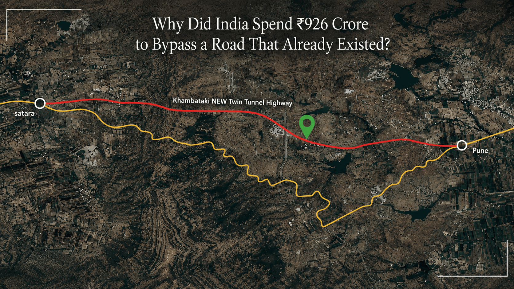
The project is the New Khambatki Ghat Twin Tube Six-Lane Tunnel on NH-48, formerly NH-4. Its package covers about 6.43 kilometres and was estimated at roughly ₹926 crore when the Ministry of Road Transport and Highways announced the project in 2022. The tunnels themselves are only part of that length. The package includes the approaches and a viaduct that reconnects the highway beyond the difficult section. Each tunnel carries three lanes in one direction.
At first glance, this looks like a straightforward infrastructure story. A dangerous road exists, so engineers build a safer road. But that misses the difficult decision underneath the project.
The old road was already there.
It had already been built, widened and maintained. The highway already connected Pune and Satara. Vehicles were already using it. So why spend hundreds of crores creating a second alignment through the same mountain?
The answer lies in the difference between maintaining infrastructure and changing its geometry.
The problem was not the road surface
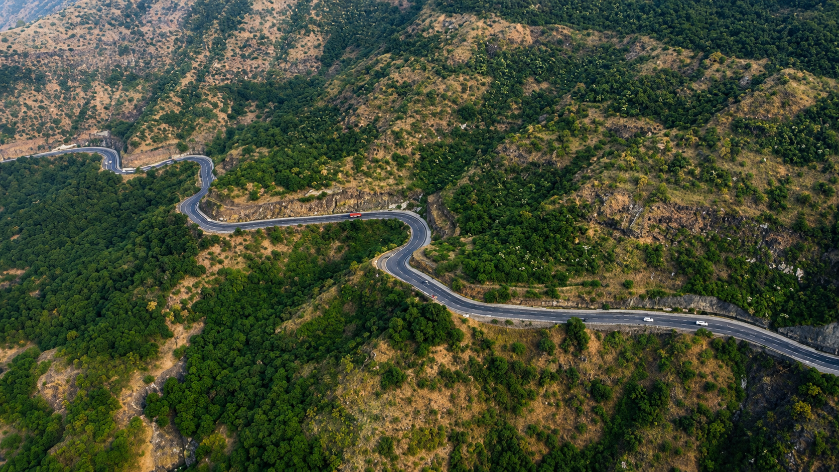
The NHAI detailed project report for the Khambatki Ghat section is unusually candid about the limitations of the existing alignment. The project area is classified as 99% mountainous. The report says the existing road has numerous horizontal and vertical curves, that several locations do not provide the required sight distance and that the curve radii are deficient against present national highway standards. It also notes that the existing alignment may have originally been designed to state highway standards that no longer matched the requirements of the national highway corridor.
That distinction matters.
A road can be in good physical condition and still be a poor road.
Resurfacing can repair damaged pavement. A new guardrail can reduce the severity of a crash. Better signs can warn drivers. Lighting can improve visibility. None of those measures changes a steep gradient or an S-shaped curve that forces a heavy vehicle to negotiate a difficult transition at the bottom of a hill.
The NHAI report says the existing eight-hundred-metre ghat section took more than 20 minutes to cross and identified 64 dangerous points on the wider Satara-Pune stretch, many involving sharp or blind turns where vehicles could lose control. It also concluded that once the new tunnel was built, the existing ghat would no longer be required for the main through movement.
This is the point at which the economics of infrastructure changes.
If the problem is deterioration, maintenance is usually the rational answer. If the problem is geometry, maintenance has a ceiling. At some point, engineers are no longer trying to make the existing road perform better. They are trying to design a different route that avoids the constraint altogether.
Khambatki crossed that threshold.
The government did not decide that the old road was worthless. It decided that the strategic function of the corridor required a better alignment.
That is a much more expensive decision, but it can also be the more rational one over the life of the infrastructure.
The tunnel was decided before the tunnel was designed
The most important part of the Khambatki project may have happened before excavation began.
The original NHAI study considered different tunnel alignments. The detailed project report identifies three alternatives and evaluates them across engineering, environmental and social considerations before arriving at the proposed alignment. In one stage of the study, a 6.46-kilometre alternative was estimated at ₹571.56 crore. The eventual project cost cited by the ministry several years later was around ₹926 crore, reflecting later development of the scheme and project conditions.
That difference is a useful reminder that an infrastructure project does not emerge fully formed from a drawing board.
Before a contractor starts drilling, engineers have to answer a more consequential question: where should the road actually go?
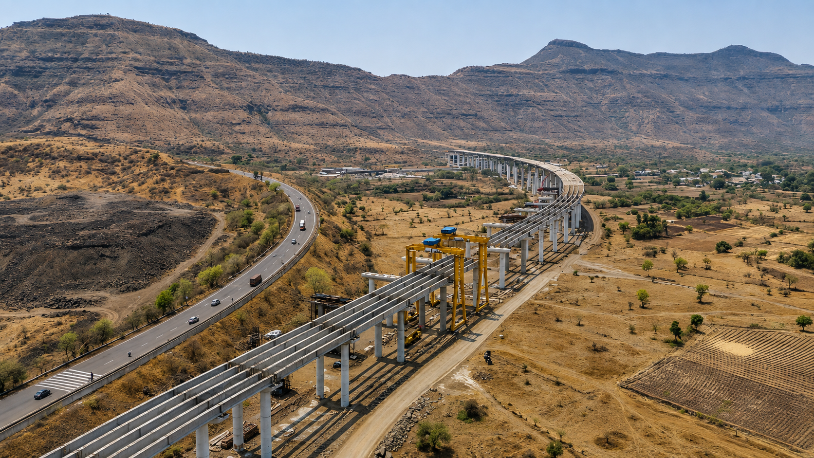
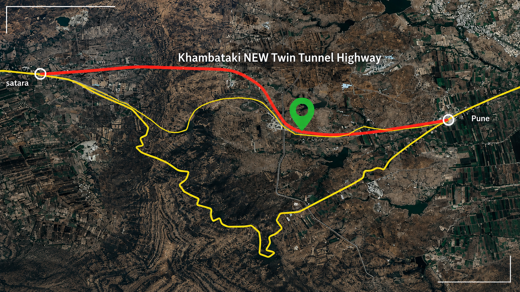
At Khambatki, the existing road approached the mountain through one alignment and crossed it through another. The NHAI report proposed straightening both directions by constructing twin tubes, each carrying three lanes. The proposed design also includes a viaduct, a 420-metre realignment and additional underpasses and structures to connect the new route back to the existing highway.
That is why the project should not be described simply as "a new tunnel."
The tunnel is the most visible part of a larger alignment intervention.
Changing a road through a mountain changes everything around it. The approach gradient changes. The point at which traffic enters the tunnel changes. The exit geometry changes. Structures need to be positioned differently. Land requirements change. Construction access changes. Traffic management changes.
The capital cost follows from those decisions.
In other words, the ₹926 crore was not spent merely to create 1.3 kilometres of underground road. It paid for a new way of moving traffic through one of the most constrained sections of the corridor.
That distinction is important when public infrastructure is judged by its headline price.
The numbers make more sense when the road is treated as a business system
When the ministry announced the project in 2022, it said the Pune-Satara direction through Khambatki Ghat could take around 45 minutes, while the opposite direction averaged 10 to 15 minutes. Once the new tunnel was operational, the expected travel time through the section was estimated at roughly 5 to 10 minutes.
By January 2026, one of the new tunnel tubes had entered trial operation, and NHAI officials told Times of India that the full crossing could be reduced to about seven minutes. The trial included a 1.3-kilometre tunnel and a 1.2-kilometre viaduct.
Reducing a highway bottleneck from something measured in tens of minutes to something measured in single digits has consequences beyond the driver's watch.
A truck climbing a steep ghat consumes more fuel and places more demand on its engine, brakes and drivetrain than it would on a controlled-gradient route. A vehicle stuck behind a slower heavy vehicle loses time even when no formal traffic jam exists. An accident on a constrained section can close the road for hours and send traffic onto an alignment that was never designed to absorb the same volume.
The Ministry has explicitly linked the project to lower fuel consumption, reduced vehicle wear and lower maintenance costs. Its April 2026 update also described improvements in connectivity for local commuters, trade and tourism.
This is why highway investment should not be assessed only by asking how much it costs to construct a kilometre.
A better question is what the corridor costs to operate without the investment.
Suppose a truck saves 30 minutes on a trip through the ghat. That saving has a value even if the truck operator never pays a rupee directly for the new tunnel. It affects fuel use, driver time, vehicle utilisation and delivery schedules. Multiply the saving across thousands of daily vehicle movements and the economics become much larger than the toll or construction cost visible to an individual passenger.
The same logic applies to reliability.
A journey that takes 10 minutes almost every time can be more valuable to a freight operator than one that takes five minutes on a good day and 40 minutes when traffic, weather or an accident intervenes.
Infrastructure earns part of its value by reducing uncertainty.
Khambatki is a good example of that principle.
A safer road is often a different road
The 2018 accident concentrated attention on the S-curve, but the underlying problem was broader.
The NHAI report describes an existing alignment where the terrain is almost entirely mountainous, where vertical gradients are steep and where sight distance is inadequate at several points. The road includes both horizontal and vertical curves because it follows the shape of the existing terrain.
That is a difficult constraint for a national highway carrying modern traffic.
A road built through mountainous terrain has to negotiate a physical compromise. Engineers can extend the route to reduce gradients, cut into slopes, build retaining structures or use tunnels and bridges to straighten the alignment. Each option costs money, consumes land and creates its own construction and environmental problems.
Khambatki uses the most expensive of those tools because the terrain makes the cheaper ones less effective.
The new twin tubes provide three lanes each, with a design carriageway width of 10.5 metres. The NHAI design includes footpaths behind barriers, service ducts, drainage, emergency lay-bys, SOS niches and other systems required to operate a high-capacity tunnel rather than simply create an opening through rock.
There is a practical reason for this level of detail.
A highway tunnel cannot be judged only by whether vehicles fit inside it.
Once a road moves underground, ventilation, drainage, fire response, emergency access, lighting, communications and evacuation become part of the road itself. A tunnel is a transportation system enclosed within a structure.
That is why the cost of the project cannot be understood from the excavation volume alone.
There was an environmental cost too
The argument for a tunnel can sound straightforward until the mountain becomes more than an obstacle.
The project passes through Khambataki Reserve Forest. The original NHAI environmental study identified 5.90 hectares of forest land and 29 hectares of non-forest land within the proposed project area, for a total of 34.90 hectares. It estimated that 336 trees would be affected and proposed more than 5,000 trees to be planted as part of the mitigation plan.
The report also estimated roughly 1.683 million cubic metres of waste soil from construction, of which about 561,000 cubic metres could be reused within the project. It estimated the project's water requirement at approximately 119 million litres during construction.
These numbers are easy to overlook because the finished tunnel hides most of the construction activity.
But underground construction does not make environmental impact disappear.
It changes where the impact occurs.
Rock has to be excavated. Spoil has to be transported and stored or reused. Roads have to be built for construction access. Machinery has to move through the site. Water has to be supplied. Noise and dust have to be controlled.
The environmental assessment therefore sits alongside the engineering design rather than outside it. The NHAI report describes a process involving surveyors, design engineers, environmental specialists and social-impact specialists, with additional coordination required with departments dealing with forests, revenue, pollution control and policing.
That is another reason a tunnel project takes years.
The physical tunnel may be measured in kilometres.
The decision-making system around it is much larger.
The project took longer than the original promise
In July 2022, the Ministry said the 6.43-kilometre project was expected to be completed by March 2023.
It was not.
By January 2026, one tube had entered trial operation while the other was still being completed. NHAI officials told local media that both sides and the associated infrastructure were expected to be operational by June 2026. An April 2026 PIB release said physical progress had reached 86% and that the project was on track for inauguration in the first half of the year.
The delay is not a footnote to the story. It is part of the story.
Large infrastructure projects are often announced with a construction duration that assumes a relatively clean sequence of work. Actual delivery has to contend with design decisions, site conditions, approvals, traffic management, access, procurement, labour, weather and events that were not part of the original baseline.
Khambatki also had an unusual constraint: the existing highway had to keep functioning while the new route was being built beside it.
That creates a basic project-management problem. The project cannot simply close the corridor and take over the mountain. Construction has to happen around live traffic, with safety requirements that change depending on which section is being worked on.
By January 2026, the trial opening itself was being used as part of the construction and safety process. Light vehicles were allowed through one tube while work continued on the remaining sections. The approach reflects a common feature of major infrastructure projects: commissioning is not a single event at the end. Systems are tested, traffic is introduced in stages and remaining work continues around an operating asset.
The public tends to see a project as either open or closed.
The project team experiences many intermediate states.
The road that remains has not disappeared
There is an interesting question about what happens to the existing Khambatki route after the new alignment takes through traffic.
The NHAI DPR was explicit about the intended purpose of the new route: the existing ghat section would no longer be required for the main through movement once the tunnel was constructed.
That does not mean the old infrastructure ceases to matter.
Road networks rarely behave like replacement parts in a machine. An old alignment may still serve local traffic, provide an alternative route during emergencies or remain useful for access to settlements and surrounding areas.
This is one of the less visible benefits of creating a new high-capacity route. The road system gains redundancy.
That can matter enormously during an incident.
If a truck breaks down in a constrained tunnel, the consequence is different when there is another route available than when the same road is the only path through the mountain.
Infrastructure planners often talk about capacity in terms of how many vehicles a road can carry. Resilience adds another dimension: how well the network behaves when something goes wrong.
A second route can therefore have value even when it is not used at full capacity every minute.
The same principle appears in power grids, data networks and water systems. Some of the infrastructure you pay for is there not because it is always needed, but because its availability changes what happens when the primary system fails.
What Khambatki says about the economics of old infrastructure
India has built thousands of kilometres of roads over several decades. Many of those roads are now carrying traffic volumes, vehicle mixes and operating speeds that their original designs did not anticipate.
Khambatki represents one version of the problem that will recur more often as the network matures.
There is a difference between maintaining an asset and upgrading the function it provides.
Maintenance attempts to preserve performance.
Upgrading changes the performance requirement.
That distinction becomes important as infrastructure ages.
An old bridge may still stand but have insufficient capacity for present traffic. A four-lane road may still function but become a bottleneck because traffic demand has grown around it. A tunnel may remain structurally sound but connect to an alignment with poor geometry.
In each case, the cheapest option in the short term may not be the cheapest option over the asset's remaining life.
The Khambatki project is effectively a bet that changing the alignment will deliver enough value through safety, travel time, operating cost and reliability to justify the capital required to build it.
That is why the project's price should be compared with the cost of the constraint it removes, not merely with the cost of maintaining the old pavement.
There is also a broader lesson for project owners.
When an asset begins to underperform, the instinct is often to add another intervention to the existing configuration. More lanes. More barriers. More repairs. Another signal. Another retrofit.
Sometimes that is exactly right.
Sometimes the configuration itself has become the problem.
Recognising that early can prevent years of spending on improvements that never address the original constraint.
The tunnel is the visible answer to an invisible planning decision
The new Khambatki tunnel will eventually become an ordinary part of the Pune-Satara highway.
That is what good infrastructure tends to do.
Drivers will enter the tunnel without thinking about the alignment alternatives that were studied before construction. They will not see the NHAI road inventory that identified deficient sight distances and curve radii. They will not see the environmental assessments, land plans or construction schedules. For most users, the project will compress into a few minutes of driving.
That is the point.
The infrastructure will have taken a difficult physical problem and converted it into an ordinary movement.
For the construction industry, the more interesting part is everything that had to happen before that ordinary movement became possible.
The original road had reached a point where its geometry imposed costs that resurfacing could not remove. The government therefore chose to create another alignment rather than continuously modify the old one. Engineers evaluated alternatives, designed twin tunnels and associated structures, considered environmental and social constraints, and then managed construction while the existing highway continued carrying traffic.
The tunnel is the final expression of those decisions.
The real project was the decision to change the route.
That is why Khambatki is a useful case study in infrastructure management. It demonstrates that the most consequential construction decision is sometimes made before construction begins, when someone decides that the existing asset is no longer capable of performing the job the network now demands from it.
A road can survive for decades and still become obsolete in one very specific way.
Its surface may be repairable, its alignment may not be.
Continue reading with Bridging Room
Bridging Room examines the engineering and management decisions behind the projects changing India's built environment. For more reporting on highways, tunnels, construction technology and infrastructure delivery, explore the latest stories from Brenman Consulting.